
The Earth’s crust is not immobile. Planet-scale movements occur due to the shifting of lithospheric plates, which slowly alter the position and extent of continents and oceans. For millions of years, the African plate, which includes part of the Mediterranean seabed, has been moving northward toward the Eurasian plate at a speed of about one centimeter per year. Subduction zones form where tectonic plates converge, with one plate sinking beneath the other until it melts into the Earth’s mantle.
The subduction process is still active beneath Calabria. This phenomenon is the main cause of the region’s significant tectonic uplift and seismic activity. Over the last 330,000 years, the regional uplift rate has been approximately one meter every 1,000 years. During the Middle and Upper Pleistocene, sedimentary fossil deposits formed along the coasts as the sea gradually lifted them, creating a series of “marine terraces” now visible on land. The oldest marine terraces are also the highest.
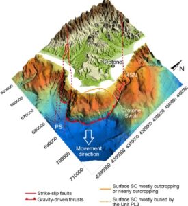
This regional uplift is complicated by a local phenomenon known as the “Crotone megaslide”, which causes subsidence along a coastal section tens of kilometers wide and approximately 1.6 kilometers thick. The magnitude and speed of this southeastward displacement vary, occurring at a rate of a few millimeters per year (Fig. 1).
The area’s geodynamic framework is, therefore, the result of complex interactions between regional and local tectonic processes. However, to fully understand a coastline’s history, another variable must also be considered: eustasy, the global rise or fall in sea level.
The total mass of H2O on Earth, in its various forms, can be considered constant, although it has changed throughout geological time. While we typically distinguish between five oceans (Pacific, Atlantic, Indian, Arctic, and Southern), they are essentially a single body of water whose volume fluctuates primarily due to climate. During glacial periods, large quantities of water were stored in expanding ice sheets and mountain glaciers, causing a global drop in sea level. Numerous glaciations have occurred throughout Earth’s history. The last glaciation peaked around 20,000 years ago, lowering sea levels by approximately 120-130 meters compared to today.
By convention, the climatic improvement that marked the end of the last glacial phase also signals the end of the Pleistocene and the beginning of the Holocene, around 11,700 years ago. Throughout the Holocene, ice sheets retreated globally, and sea levels rose at varying speeds, eventually reaching their current position.
If we imagine hammering a nail into the sea level of a tectonically stable rocky coast, we would call the sea’s advance onto the coast during warmer climate phases a transgression, and the sea’s retreat during colder phases a regression, due purely to eustatic reasons. However, if the rocky coast experiences vertical tectonic shifts (uplift or subsidence), as in Calabria, the movements of both the coast and the sea level must be algebraically summed to determine what actually happens to the nail. This local sea level movement is known as “relative sea level”.
Changes in relative sea level alter the coastline and significantly affect sediment dynamics (erosion and deposition), geomorphological processes, the distribution of marine organisms, and, ultimately, the location and extent of human settlements tied to the sea.
By understanding the morphology of the seafloor, we can reconstruct past coastline changes by lowering the relative sea level. Off the coast of Le Castella, lowering the sea level reveals small islands that currently correspond to accumulations of calcarenitic boulders on the seabed. These boulders are the remnants of Pleistocene calcarenitic layers that once formed the islands, which were dismantled by wave action when the sea submerged them (Fig. 2).
