Archaeology can also provide a valuable contribution to the study of coastal changes over the past millennia in relation to sea level fluctuations and shoreline erosion and advance.
To reconstruct these events, scientists rely on four main types of indicators: geomorphological, geological, geochronological, and archaeological. However, while the first three are useful for framing and dating phenomena, including those dating back to the last interglacial period around 125,000 years ago, archaeological indicators are mainly available for the last 2-3 millennia and rarely extend back to the last glaciation (20,000 years ago).
In order to trace the evolution of coastlines, archaeology in the Mediterranean mainly investigates ancient coastal settlements, which are a testimony to the many cultures that have succeeded one another over the centuries along its shores.
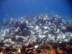
For example, to study sea level changes, geoarchaeological indicators can be obtained from ancient coastal settlements that possess specific characteristics: good conservation status and a topographical location that has not undergone geological alterations due to earthquakes, landslides, volcanic activity, etc. Archaeologists seek to identify on ancient submerged structures the levels of specific architectural elements that, due to their function, can be related to the level of the local mean sea level when they were built.
As an example, several types of structures now submerged due to sea level changes can be encountered by archaeologists: a mooring bollard can suggest the approximate position of the sea level that was functional to it; the same can be said for a sluice belonging to a Roman fishpond that once regulated the flow of seawater, which precisely indicates the sea level when it was constructed.
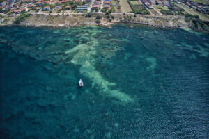
There are many sites that can provide such indications, including jetties and launching structures of harbors, specific areas of coastal villas, the previously mentioned fish farming installations, coastal quarries, and more (figs. 1, 2).