
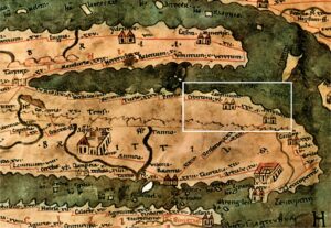
The earliest cartographic representation of the Crotone Peninsula appears in the Tabula Peutingeriana (VI, 2), a Roman road map from the 4th century AD, of which a medieval copy has survived. Along the coastal road connecting Taranto and Reggio, the map marks the city of Crontona, the Lacenium sanctuary, and Annibali (Fig. 1). The latter, identified with Le Castella, refers to the encampments built in 205 BC by the Carthaginian commander Hannibal for his army before his final departure for Africa.
After antiquity, several centuries passed before new cartographic representations of the Crotone coast appeared in Atlases and Nautical Charts, including those by Francesco De Cesanis (1421), Giovanni Xenodocos from Corfu (1520), and the cartographer Battista Agnese, who authored the Atlas of the World (1536) and the Nautical Atlas (1553).
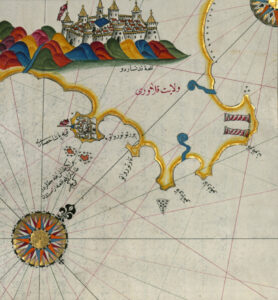
One of the most significant 16th-century cartographic documents is the Kitāb-i Baḥriye (The Book of the Sea) by Ottoman geographer Piri Reis. Several versions of this work exist, and in the table describing the stretch of sea between Capo Colonna and Punta Stilo, two small islands appear in front of Le Castella, with their perimeters marked by rocky shoals.
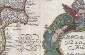
Advancements in cartographic representation became evident in the 17th century. One noteworthy map is the Carta del Regno di Napoli by Giovanni Antonio Magini (1620), where the Crotone Peninsula, now featuring numerous toponyms, begins to take on a recognizable shape (Fig. 2).
A scientifically accurate cartographic representation of the Crotone Peninsula, however, did not emerge until the work of Giovanni Antonio Rizzi Zannoni. In 1789, he created Sheet No. 29 of his Geographic Atlas of the Kingdom of Naples, depicting the Ionian coast from Torre di Melissa to Torre di Catanzaro in remarkable detail. The map highlights the promontory of Crotone and the rocky headlands of T(orre) and C(apo) di Nau, Capo delle Colonne, Capo delli Cimiti, Capo Rizzuto, and Le Castella. In the latter area, the coastline is depicted using the “chipping” technique to visually convey the sheer cliffs overhanging the sea (Fig. 3).

In addition to the Geographic Atlas, Rizzi Zannoni later produced the Maritime Atlas of the Two Sicilies in 1792.
If we could travel back in time about five centuries, to the early 16th century, we would see two rocky areas emerging just a few hundred meters behind the Aragonese fortress of Le Castella. These two small islands represented what remained of a large marine terrace that had once extended into the sea but sank due to various geological and geotechnical causes over millennia.
We have several testimonies of these geological formations in cartographic documents of Ionian Calabria created between the 15th and 16th centuries. These are, of course, schematic representations, but they leave no doubt about their actual existence (Fig. 1).

We also have traces of the two emerged areas in some portolans dating from the late medieval period to the early 18th century. In the Portolano Rizo (1490), for example, it is noted that “Chastele e cita e sovra le castelle a mio uno sono di ixolete et intorno vi sono molto aspreo.”
The most detailed description of the small islands can be found in the text accompanying the Kitāb-i Baḥriye by Ottoman geographer Piri Reis, dated to the early 16th century. In the manuscript ms. Istanbul, Ayasofya Kitapsaray, 2612, regarding Le Castella, we read: “Moreover, on a (sort of) peninsula, there is still a promontory; within the said promontory, there is a village, which they call Qastàlò. On both sides of the village, there are two coves. These coves are a good anchorage for small boats. A mile ahead, there are two small islands. The space between the two small islands and the fortress is passable by boats (although) the side of the two islets is littered with rocks” (trans. D. V. Proverbio) (Fig. 2).
It is possible that these and other small islands once present along the Crotonese coast are faintly mentioned in ancient Greek-Roman sources. Pseudo-Skylax, in a Periplus dated between 338 and 335 BC, recalls the island of Calypso off Capo Colonna, where Odysseus dwelt. Pliny the Elder, in Book III of the Natural History (1st century AD), lists five islands off the Lacinio promontory (modern-day Capo Colonna), providing their names: Tyris, Eranusa, Meloessa, Dioscoron, and Calypso.